| Top | Master Plan Contents |
Chapter 4: Park Restoration and Improvement Strategies
INTRODUCTION
The master plan recommendations are the result
of months of discussion, and a planning process
that included a number of public forums as well
as meetings with the Advisory Committee, city
staff and interested individuals. The people who
attended the meetings expressed a clear desire
for a park that would be full of exciting events
and activities, attracting families, groups and
individuals. For many, this vision of the park is
reminiscent of the happy memories they share
from earlier times, when families spent a whole
day enjoying the range of activities offered at the
park.
The plan offers suggestions for new programs and activities, balanced with respect for the ecology of the park and the rich historical context that is still very evident here. The restoration approach is aimed at accommodating community interests while preserving and maintaining the natural and historic elements that give the park its essential character.
The recommendations that follow are presented as: 1) a series of physical improvements and changes to park infrastructure; 2) new programs and activities; 3) recommendations for an implementation strategy, including community involvement, park management and key projects, and 4) recommendations for landscape maintenance and management.
Figure 50 illustrates the Master Plan for Cadwalader Park. Additional figures illustrate more detailed proposals for specific areas of the park.
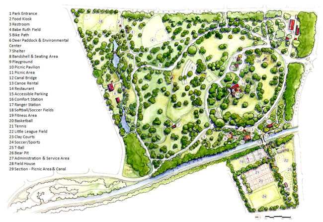
Figure 50: Master Plan for Cadwalader Park
| Top | Master Plan Contents |
PARKWIDE RENEWAL
Park History
The historical significance of Cadwalader Park derives from the prominence of the Trenton citizens who built the Ellarslie estate, as well as its early park development at the hands of Frederick Law Olmsted and his sons. Features from both of these eras are still present in the park (Figure 22: Contributing Historic Resources).
Preservation of these significant elements is crucial to maintaining the historic character of the park and should be a top priority in its rejuvenation. New elements should respect thehistorical design traditions by utilizing materials and styles characteristic of the park’s history.
Actions that need to be taken to preserve the park’s history are as follows:
• Stabilize, preserve and interpret the features attributed to the Olmsted plan, including the circuit drive, the Parkside Avenue entrance and bridge and the east ravine.
• Restore and interpret the west ravine and pools, which are part of the Olmsted plan.
• Stabilize, repair, and interpret the historic park buildings, including Ellarslie, the Cottage, the small animal barn and the Maintenance Garage(at this writing, restoration of the West End Restroom is nearing completion).
• Stabilize and preserve additional park structures including the Stuyvesant Avenue Gate, the old band shell foundation, and the canal stairways.
• Repair and adaptively reuse the large animal barn, the Comfort Station, and the Ranger Station.
• Remove unsafe components of the Bear Pit and interpret both the Bear Pit and Briar Patch marker.
• Replace the existing Picnic Pavilion with at least one new structure, appropriate to the park’s historic character.
Park Ecology
Cadwalader Park, at present, is not experiencing
the kind of active deterioration common to more
heavily used urban parks. Its status might be
described as a gradual decline that will become
more evident as the current mature trees die off
while the maintenance and support staff are
stretched further to perform increased routine duties.
The restoration of ecological values for Cadwalader Park hinges on the ability of those who are directly involved in its care to perceive the park as a living system. This will require, above all, an education program aimed at having the groundskeepers and support staff recognize that they are instrumental in ensuring the future health and survival of the park. Raising the level of commitment and standard of care of the people who care for the park every day is the first, essential step toward restoring the park and developing a level of public awareness that will help sustain the renewal.
Several of these recommendations are mentioned under the sections for vegetation or landscape management; they are included here for emphasis.
• Implement a park-wide landscape management plan to ensure that no areas of the park are neglected by maintenance and that the overall level of care is raised significantly.
• Initiate new staff training programs that build landscape skills and instill a sense of commitment to the vitality of the park.
• Develop and implement a tree management program and planting plans that utilize information from the historical design plans and documents, modern urban forestry science as well as traditional arboricultural
methods.
• Develop a volunteer corps for projects such as woodland management, slope stabilization, and soil decompaction that can be a vehicle for developing skills in the community.
• Continue to develop connections with local environmental groups, community groups, state forestry programs, urban renewal programs, and other groups that can conduct restoration work hops or contribute ideas and resources.
Access and Circulation
The Parkside Avenue entrance and the historic circuit drive are retained as essential features that establish the overall spatial coherence for the park today. The two interior park roads near the picnic grove are replaced by a single, one-way drive that offers handicapped access to Ellarslie and access to the proposed concert area. Although the new drive is a significant change from the present plan, it greatly simplifies the interior circulation and shifts vehicles away from the immediate surroundings of Ellarslie. Sincethe drive begins near the Ranger Station, it may be possible to utilize that building as a convenient source for park information. The elimination of the “innerloop” created by the two drives will also reduce the extent of traffic in the park since vehicles will be able to use the drives for entering, parking, and exiting only (Figure 51). |
|
• Remove the traffic circle at the Parkside entrance and reconfigure the drive intersection as an “in-out only” route to eliminate cruising around the loop of park drives.
• Retain the circuit drive as a pedestrian route with the option of utilizing one half of the drive as parking for special events. The bollards remain in their present locations to close the drive to vehicles.
• Develop a new internal drive that replaces the two existing drives around the picnic grove and provides access to Ellarslie and the new concert area. This new drive will flow in a one-way direction, entering at the Parkside
Avenue entrance passing Ellarslie and the playground/picnic area and ultimately exiting at the point of entry.• The new drives, and future asphalt repaving, should be asphalt with a chip-seal surface of local crushed stone. Curbs should be granite cobble, as used historically.
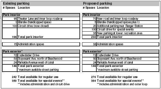
Table 4: Existing and Proposed Parking
Parking
Most of the parking shown is parallel parking on existing park roads. Table 4 shows the available parking within the park for normal use, as well as possible event use within the park and the adjoining neighborhoods.
• Develop accessible parking for several cars and at least one service vehicle at Ellarslie.
• Allow parallel parking along the internal park drive and the section of the circuit drive between the playground and the Parkside entrance.
• Develop parking on reinforced turf for 15–20 cars between Ellarslie and the Ranger Station.
• Develop a new parking area for about 35 cars in the lower recreation area between Lenape Avenue and the tennis courts.
• Utilize street parking on Cadwalader Drive and Stuyvesant Avenue for concerts and large events. For special events at designated times, also utilize the outer circuit drive for parking.
Walkways
The proposed continuous loop path, echoing the Olmsted method of providing separate systems of roadway and path, is a major addition to the system of park paths. Other major pedestrian routes will provide clear routes across the west meadow and path access to the restored stream and lake. The entire path system should be linked to provide a continuous means of pedestrian travel through the park.
• Develop a one-way, continuous, multipurpose loop path, either on the circuit roadway or adjacent to it, for walkers, bicyclists and skaters.
• For new paths, develop a rational hierarchy of paths for various uses. Pedestrian-only paths would be eight feet wide while multiple use paths, which might also be used by service vehicles, would be ten to 12 feet wide. Pedestrian paths, depending on location, grade, and ADA requirements, could be asphalt, or gravel, to match existing paths. Multiple-use paths could be asphalt-surfaced. Asphalt would be chip-seal finished to match new roads.
• For existing paths that are to remain, restore the original cobble stone curb and repair the gravel surfacing. New paths in the vicinity of the upper pond that connect to the old paths should be constructed of similar
materials.• Remove dead-end paths that are not part of a continuous circulation system, except where they are used to enter buildings.
• Install entrance markers at all secondary park entrances.
Utilities and Stormwater Management
Storm and sanitary sewers within the park are in
serviceable condition although several repairs are
needed, as noted in the Technical Memorandum.
A priority item is to locate and repair the source
of contamination to the upper pond, which is
especially important in view of the proposed
public access to the environmental center and
restored stream and pool system.
• Determine the source of sanitary contamination of the upper pond and west stream and repair the lines.
• Replace sanitary system manhole covers with solid covers and remove trash pans below.
• Clean sanitary lines and perform television inspection to determine condition of the system.
• Clean and inspect all storm drains and repair or replace loose or broken catch basin grates.
• Replace/repair outfalls for the upper pond, lake, ravines and canal.
• Install a new gravel drain system between the tennis courts and Lover’s Lane and connect it to the existing storm system.
• Connect the existing separate waterlines into a looped system by installing lines and valves.
Vegetation
Trees
The park’s mature deciduous shade trees are probably the foremost character-defining feature of Cadwalader Park and remain high on the list of desirable features among regular park visitors. The decline of the spectacular deciduous shade trees, such as white oak and beech, is a serious concern. Many of the trees used for replacement, such as Norway spruce, are lacking in landscape value or historic character.
A primary recommendation for the trees is to
begin active management of the valuable, large
shade trees that can benefit from pruning or
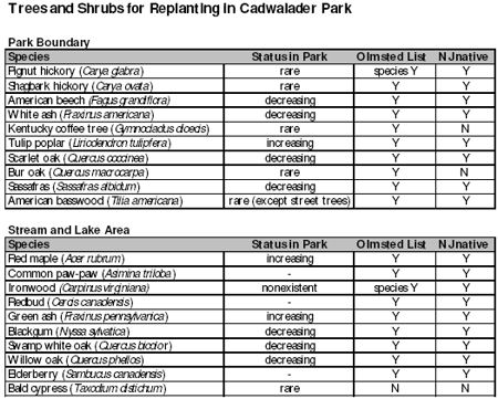
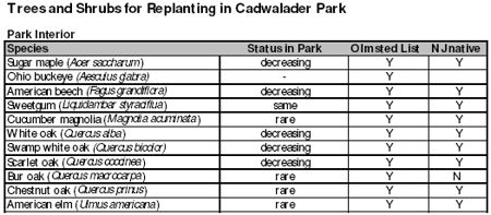
disease management. Selective removal of A second major recommendation is the development of a replanting strategy, developed according to park zone, for the entire park. New trees should be planted on an annual basis, selected from a list of trees that are appropriate from both a historic and ecological perspective. Tables 5 and 6 list trees and shrubs for planting within major park zones. |
|
• Develop a management program for pruning, fertilization and removals, as discussed below in Landscape Maintenance.
• Develop a planting plan for the park, with the distribution of trees to reflect historic groupings and vistas. Trees should provide shade for roadways and picnic areas, emphasize vistas, and stabilize eroded areas and streams. This would include gradual removal of unhealthyor inappropriate trees, such as Norway Spruce and Norway Maple. It is important to note that the Olmsted plant lists for Cadwalader Park do not include any ever green trees.
• Begin to restore the balance and diversity of tree species by planting trees that were part of the park’s earlier history and have since decreased in the park. Examples include oak, beech, hickory and elm (new hybrids are more resistant to Dutch elm disease).
• Conduct planting on a regular (if possible, on an annual) basis, to ensure a range of various aged trees for the future. Approximately 1,000 trees, planted over a 15-year period, will be required. This would result in a replanting program of about 60–70 trees annually, to implement master plan concepts and replace dying trees (park-wide, not including special restoration areas or woodlands).
• Cease planting non-historic, overplanted species such as Norway maple, London planetree, pine, and Norway spruce.
Woodlands
Park woodlands are small and concentrated along
stream corridors, as well as the canal, leaving
them vulnerable to disturbance from erosion and
infestations of exotic species. Although budgets
for these areas might be modest, thoughtful,
timely intervention is more critical than money
when implementing a woodland management
program. Some work may be performed by
teams of volunteers, under the direction of the
city landscape architect or an experienced urban
forester.
• Working in one area at a time, gradually remove the most noxious invasive species, such as Norway maples. If the ground is disturbed or canopy gaps are opened by removals, planting of native woodland plants from the historic plant lists should follow immediately.
• Begin to reestablish the shrub and understory layers that are presently underrepresented in the woodlands with native woodland plants from the historic plant lists.
• Monitor the few canopy gaps that exist and, when the budget permits, plant groves of small trees to gradually fill these in.
• Gradually remove the asphalt from the leaf dump area and remove other debris and trash as soon as possible after it appears.
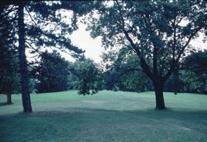
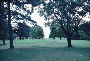
Vistas Views across the expansive, rolling meadows toward the canal and river were important in the early years of Cadwalader Park and were a major focus of the historic Olmsted plan of 1891. As a result of the surrounding development, the river is no longer visible from the park. In addition, plantings of trees over the years, particularly evergreens, have closed in all of the long views within the park. Vista management should be performed very gradually, in conjunction with the rest of park management, and the results should be carefully monitored, recorded and evaluated as work progresses. • Historic vistas should gradually be opened, which would involve selective tree pruning and removal of inappropriate and unhealthy trees, and trees which block the historic views. • Vista management should, first, identifythe original design intent for the space or vista and second, identify trees that could be managed through pruning. Following initial pruning, selected trees based on crowding, health, inappropriate species or location should be removed. Removals should be conducted gradually, on an annual basis, and the effects evaluated before proceeding any further. • Locations of new plantings should respect the original historic design intent for park
sightlines and potential major vistas. A computer simulation of proposed vista management is illustrated in Figure 52. |
Figure 52: Vista from west meadow; |
Buildings
Rehabilitation and adaptive reuse is the major focus of the program for the buildings at Cadwalader Park. Several new park structures are proposed, specifically a new performance stage, new picnic pavilions and rest rooms, and an outdoor terrace at Ellarslie, covered by a trellis, to serve as a park restaurant. The new buildings and structures should express a design style compatible with the other early 20th century park structures, such as the Comfort Station and Fieldhouse.
• Stabilize and repair the Cottage, the Fieldhouse, the small animal barn, and the press stand at the Little League Field. Install fire systems in all enclosed buildings.
• Prepare five-year and ten-year maintenance programs for all buildings and structures and incorporate these into the park’s operating and capital improvement budgets.
• Renovate the Comfort Station and the Ranger Station to serve, respectively, as accessible restrooms and a ranger/information station. Conduct renovations in accordance with the US Secretary of the Interior’s
Standards and Guidelines for the Treatment of Historic Properties and Guidelines for the Treatment of Historic Landscapes.• Adaptively reuse the large animal barn as an environmental center for the park. Develop architectural plans in accordance with the US Secretary of the Interior’s Standards and Guidelines.
• Construct a new performance stage in the location of the former structure to accommodate a program of outdoor theater, dance and concerts.
• Develop a space utilization program and design for the outdoor dining terrace at Ellarslie, in the location shown on the 1891 Preliminary Plan for Cadwalader Park, in accordance with the US Secretary of the Interior’s Standards and Guidelines. Include a trellis for shade, as proposed in the 1891 Olmsted Plan.
• Design and construct the new pavilions, rest rooms and food kiosks in a style compatible with early 20th Century park design and the existing historic building within the park.
Structures
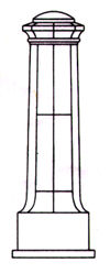
• Repair and repoint masonry on Parkside Avenue Bridge. Replace urns with exact copies of originals to match existing photo documentation.
• The Bear Pit is an historic feature in the park, although representative of poor and archaic animal management. It is currently in very poor condition. Remove unsafe structures and make the area safe and secure. Place an
interpretive sign at the Bear Pit near the Briar Patch grave marker.• Clean and repoint the park monuments, as recommended in the Technical Report for Buildings and Structures for Cadwalader Park
• Develop a rustic design for the new wood bridges across the stream and pool system on the west side of the park, similar to that used by other late 19th/early 20th Century urban parks.
• Construct a new canal bridge, in an appropriate historic style, in a new location to serve the redesigned picnic area and link to Lover’s Lane. Although the Olmsted plan of 1891 separated the canal from the park, the master plan reconnects the upper and lower parks through reestablishment of the bridge and establishment of new paths. Heavy pedestrian use of the slopes between the lower and upper park (Figure 35) has created erosion and desire lines which need to be appropriately developed to reflect the modern community’s need to integrate the two parts of the Park. Careful consideration needs to be given to the design of this new bridge. Historically, a wood swing bridge was present. The aesthetic effect of this design on restoration guided by the Olmsted plan needs to be addressed during detailed design. Archeological investigation and interpretation of historic canal remnants also should be part of this effort.
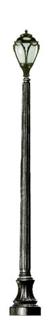
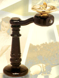
Figure 53 Proposed park light fixture and bollard |
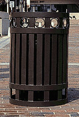
Figure 54. Proposed park furnishings |
Recreational Facilities
The recreational facilities are generally some of the best-maintained areas at the park. Major recommendations include the construction of a new playground, refitting of clay tennis courts, and construction of a new adult fitness area in a more appropriate location in the lower recreation area.
• Remove the existing playground and construct a new one in the proposed location that meets current safety and materials standards.
• Remove the adult fitness equipment and install a new fitness area next to the basketball courts.
• Working with a sponsoring organization, repair and refit the clay tennis courts to meet competition standards.
• Upgrade the bleachers and clubhouse at the Little League and Babe Ruth baseball fields.
Furnishings
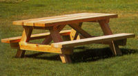
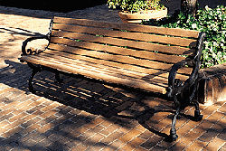
More benches and picnic tables will be needed as the revitalized park attracts more visitors. Suggested designs for benches, trash receptacles and light fixtures compatible with the park era are indicated here. Old benches and tables can be replaced as they fall into disrepair.
• Place light fixtures only in the areas that can be reliably monitored by security. Lighting should be installed on main roads and paths visible from roads for ease of security patrol. Lighting should not be installed in areas that
are not desirable for use at night or are difficult to see from roads.• Site a significant number of new benches along paths, near large shade trees, at interesting views, and near activity areas.
• Upgrade picnic tables for the proposed picnic area and group them in clusters to minimize intrusion with park vistas and pathways.
• Proposed furnishings are shown in Figures 53 and 54. Finish for painted items should be semi-gloss.
Animal Management
Since the public meetings revealed popular support for keeping deer in the park, an upgraded program of animal management is a crucial recommendation of the master plan. An animal caretaker position should be created to ensure that a staff member is available to monitor and care for the animals. Feeders and watering devices must be provided that will both maintain the deer and exclude feeding of the abundant waterfowl.
• Create a full or part-time animal caretaker position staffed by an individual trained and experienced in the care of ungulates or similar hoofed animals. This person would keep breeding and medical records, feed and monitor the herd on a daily basis, and clean the enclosure and feeding devices.
• Redesign the deer paddock, as shown in the plan, to allow for separation or capture of groups or individuals.
• Restrict the deer diet to a suitable commercially prepared diet. Install automatic feeders that will restrict feeding to the deer only.
• Provide a heated, automatic water trough in place of open tubs of water to discourage waterfowl.
Security
Upgraded security for the park was one of the
most sought-after changes by the community during the master planning process. Increased city
police presence was foremost among the needed
security items developed for the park. Security
could also be increased and maintained in several
otherways: by further developing the ranger
program, by upgrading park lighting, and by
restoring the landscape to maintain park
sightlines.
• Undertake a park-wide security review during
peak use in order to develop a coordinated
security plan.
• Develop a coordinated park security plan to include police, park maintenance staff, and park rangers.
• Provide increased, daily and regular police presence throughout the park. Encourage bicycle patrols of police during daylight hours and police in cruisers at night. Establish a base for police within the park.
• Develop a core group of full time park
rangers, supported by a seasonal group, who
would patrol particularly on weekday evenings
and weekends. Rangers should be
trained in public education as well as conflict
resolution, and should be able to issue
summonses. They should remain unarmed.
• Set up monthly park security meetings to include the park administrator, Chief Ranger, and police to review and coordinate park security.
• Develop an overall lighting plan for the park and increase lighting in designated areas.
• In accordance with the park management plan, selectively remove or relocate evergreen trees and other vegetation to increase visibility and maintain clear sightlines in to and throughout the park.
| Top | Master Plan Contents |
PARK PROGRAMS AND ACTIVITIES
Introduction
The program of proposed activities is as important to the renewal of Cadwalader Park as are the measures proposed for its physical restoration. Trees, paths, and buildings may be the back bone of the park, but people are its life blood. The people who regularly visit the park and enjoy its facilities come for many reasons. Their presence is often an attraction for other people, who might stay away if the park was perceived to be too private, and therefore, unwelcoming; or too empty, and therefore, dangerous.
The master plan proposes a full program of
events and activities to restore this lifeblood to
Cadwalader Park and make it, once more, a place
where people of all ages, abilities and interests
can spend an active hour or a relaxing day. The
park program is designed to accommodate the
suggestions of many citizens who attended the
meetings and urged the planners to make a lively,
exciting park that will attract families and reflect
the diversity of the city.
Food
Food concessions in the park will attract visitors
for longer stays and provide a social context for
casual recreation. Permanent kiosks that display a
lively and consistent design style appropriate to
the historic setting are proposed for some
locations, while temporary vendors might serve
weekend or seasonal-type visitors and events.
Different food styles are proposed to meet a
range of interests. The hot dog and popcorn fare
could continue at the lower recreation area,
perhaps in conjunction with an ethnic food
vendor. An ice cream stand might operate near
the picnic area. The seating terrace at Ellarslie
could serve a casual, more upscale menu of
sandwiches and other café-style food.
To date, there has been little interest in food
vending in the park. The present street vendors
who park inside and around the park would
compete, and could likely undersell, park vendors.
Any successful park-vending plan will entail
restricting the street vendors to outside the park.
Special one-time permits to coincide with park
events or performances should be considered to
develop a concession presence in the park.
• Provide for a variety of food in the park, to be sold from permanent kiosks, temporary vendor carts, and at Ellarslie.
• Locate the kiosks at activity centers in the park, as shown on the plan, so that they can be readily supplied and maintained.
Planned Events and Group Programs
Cadwalader is already the venue for several
popular annual events. A regular program of
more frequent events, such as a concert or
theater series, could attract a new constituency
to the park and better serve the city as a whole.
The proposed new facilities, including the performance stage and the dining terrace at Ellarslie,
could support a greater range of events than can
presently be accommodated. Planned group
events would continue in new locations, utilizing
the new picnic pavilions or the Ellarslie terrace.
Tents for weddings and other large family events
might occur on the old bowling lawns.
The following list of program activities is offered
for consideration:
• Develop programming that emphasizes the natural and historical features of the park and city.
• Initiate a variety of new events and performance series, such as “Puppets in the Park,” or the “Friday Jazz Sessions” that will appeal to a variety of age and interest groups.
• Develop a City Safari program for at-risk children grades K-3 to discover nature in the urban environment through trips to the park.
• Hold a family-day concert in the park; the performance would be geared toward the entire family, with music and picnicking for kids of all ages.
• Initiate an Arts-in-the-Parks program, a multicultural performing arts series with performances targeted for children from nursery through elementary school.
• Develop a summer film series, possibly geared to young people who have limited means to drive to suburban theaters.
• Develop a classical music/opera series, such as the Philharmonic series sponsored by Chase Bank in New Brunswick.
• Develop environmental education, gardening, historical tours, outdoor walks and cultural/arts programs.
• Continue to promote the park as a place for celebrations, family reunions, employee days, and other planned events.
Special Event Celebrations
Cadwalader was once the home of an active community cultural life. As a large and historically
significant open space surrounded by several
thriving neighborhoods, it seems appropriate to
utilize the park to help build historical continuity
and strengthen community ties. Ideas tossed
around at the meetings included ethnic day
celebrations, Trenton historydays, culturally oriented
dance or music workshops, canal events,
arts festivals and environmental celebrations.
The park is already the venue for several popular
annual events. The proposal of a new performance
area could support a greater range of
events than can presently be accommodated.
Other park locations, such as the circuit drive,
could also be considered for events.
• Consider initiating new city-wide celebrations in the park that are appropriate from the standpoint of the history of the park or its neighboring communities.
• Utilize new celebrations and events as a way to promote and celebrate the uniqueness and diversity of Trenton’s communities.
Recreational Activities
Recreational programs continuously evolve as
one generation of interests and needs is replaced by another. Group sports such as soccer, baseball,
and basketball are still popular and have a
place at the park. Newer activities that emphasize
fitness and are more individual in nature can also
be accommodated, some with relatively low-cost
improvements.
• Upgrade the adult fitness area and relocate it adjacent to the basketball courts.
• Develop the circuit path to provide a continuous loop for travel around the park. Add signage to the path to designate the roadway for faster cyclists and skaters while slower pedestrians remain on the path.
• Install appropriately designed distance markers for runners.
• Encourage boating on the canal by developing a canoe put-in near the bridge and consider having a private canoe concession.
Environmental Education
The physical restoration of the park could be the
focus of a community-based environmental
education program. The two-story deer barn
could be renovated for use as an environmental
center. The stream and lake restoration could
involve school children and other groups to
undertake research, planting, wildlife restoration,
and monitoring. The park as a whole could be
placed into a database, with records of wildlife
sightings, nesting patterns, presence of invasive
species, etc. monitored by school groups.
• Develop a monitoring program for the park as an educational activity, where school children are taught to observe and record important environmental facts.
• Maintain the monitoring record as an environmental database for the park to inform future restoration projects.
• Develop the animal barn as an environmental center and use it to support restoration projects in the park, such as the stream and lake restoration.
Ranger Program
The park rangers are presently underutilized as a
resource for the park. Rangers could function as
park greeters and educators, in addition to their
security function. Short training programs in
conflict resolution and park history/ecology would
assist them in their jobs and give them relevant,
transferable skills.
• Develop a core group of full time park rangers, supported by a seasonal group. Rangers should remain unarmed but be authorized to issue summonses.
• Give all rangers training in conflict resolution and ensure that they have a basic interpretive knowledge of the park, including its history, major trees, and hours of operation of all facilities.
• Rehabilitate the ranger station to function as a home base for the rangers and police bike/scooter patrols as well as an orientation place for visitors.
• Hold monthly meetings with the park administrator, Chief Ranger, and police to coordinate park security.
| Top | Master Plan Contents |
KEY CAPITAL PROJECTS
These priority projects reflect a balance between improvements to the park infrastructure and the planned activity program. All of them require significant capital expenditures, which might be met through targeted fund-raising efforts. Any of these projects could spearhead the overall restoration effort and, once successfully in place, build momentum for additional improvements.
Proposed Circulation and Ellarslie
Ellarslie, viewed by Olmsted as integral to the life of the park, would remain as the City Museum, with the addition of a restaurant and park information center. The City Museum would remain on the first and second floors of the mansion. The new uses would expand Ellarslie’s functions and would incorporate it more fully into the park. A new drive would provide access to Ellarslie and the concert area, eliminating the need for the two existing internal drives.
• Develop a one-way drive that replaces the two existing drives around the picnic grove and provides access to Ellarslie and the new concert area.
• Designate spaces for parallel parking along the drive.
• Provide handicapped access to Ellarslie and the Comfort and Ranger Stations.
• Provide designated parking in the area of Ellarslie and the Comfort and Ranger Stations for 25 cars, including five accessible spaces.
• Construct a stone dining terrace at the south and west sides of the building, with a trellis or other structure shading the area.
• Modernize or expand the mansion kitchen to accommodate the new restaurant/catering function. Coordinate this work with the museum’s management team.
• Provide space for information on both the park and Ellarslie in the foyer o fthe building, and staff the area with volunteers or part time docents.
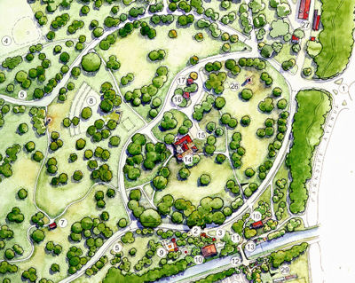
Performance Area and Vistas Park visitors and meeting attendees enthusiastically supported replacing the present movable stage with a permanent performance stage. The configuration of the proposed drive allows the direction of the stage to face the hill for seating and noise control. The removal of selected trees in this vicinity will improve visibility for the stage and will allow better sightlines and vistas to increase visibility within the interior of the park (Figure 55).
|
Figure 55. Develop a one-way drive that replaces the two existing drives around the picnic grove and provides access to Ellarslie and the new concert area. |

Canal Bridge, Picnic Grounds and Recreation Area
When the park was originally designed, the Canal Feeder was an unsightly industrial area. Olmsted’s plan, therefore, called for the area to be screened. Today’s use of the park shows clear desire lines between the upper and lower areas. New facilities shown in these parts of the park make it desirable to once again link the upper and lower areas to form a coherent, vibrant zone for park users. The existing Canal Bridge is located adjacent to the old road bridge footings and, therefore, is not in a direct line between Lovers’ Lane and the upper park. The proposed bridge makes a more visible, direct connection to reduce desire paths and subsequent erosion. The picnic area is shifted to the area above the bridge to create a more focused activity center with easy access to the lower recreation area (Figure 56).
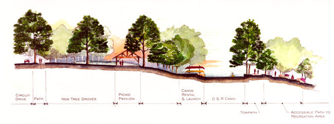
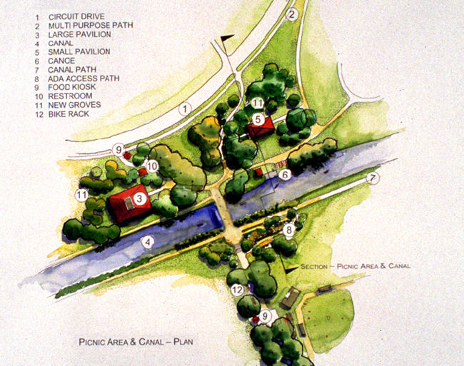
Figure 56. Detail plan & section- canal bridge and picnic area
The programming and design for this area is intended to create a place of excitement and will allow for varied activities suitable for groups and individuals. The plan shows two new picnic pavilions that will accommodate both large and smallgroups. A canoe rental facility could be sited next to the bridge for boating on the canal. Paths for pedestrians and bicyclists that are ADA accessible connect the lower park to the pedestrian loop in the upper park.
• Construct a new canal bridge as shown (in the location of the original bridge) in a style compatible with other late 19th/early 20th Century park bridges.
• Develop an accessible pathway from the lower recreation area to the bridge and fit it tightly into the hill, using boulders and native shrub plantings to stabilize the slope and create the appearance of a natural rock outcrop.
• Build two new picnic pavilions, with one pavilion large enough to accommodate family reunions or other large gatherings under various weather conditions.
• Develop a canoe rental in this area to be run on a seasonal basis by a private concession.
• Connect the upper and lower parks by paths that accommodate accessibility needs, cyclists, and pedestrians.
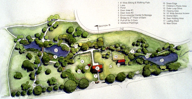
Figure 57: Detail plan – deer area and stream restoration
Deer Paddock, Environmental Center and Stream Restoration The deer paddock animal barn has been proposed for rehabilitation as an environmental education center. The plan (Figure 57) shows visitor access to the second floor from Cadwalader Drive and service access to the lower floor of the barn from the park. The deer paddock is redesigned to meet animal health and safety requirements while allowing visitors greater visibility into the paddock through a landscaped fence. The reconfigured paddock will allow restoration of the stream and lower pond as a natural wetland system, modeled after the pool and stream sequence shown in the 1891 Olmsted plan. The restoration could be incorporated as part of an ongoing environmental education program with activities coordinated to school lesson plans (Figures 58 and 59). |
|
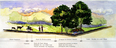
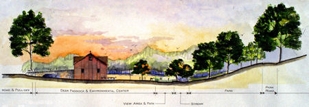
• Adaptively reuse the present two-story barn as an environmental center, with separate access for visitors and service. The building rehabilitation should follow the US Secretary of the Interior’s Standards and Guidelines for the Treatment of Historic Properties.
• Reconfigure the deer paddock to meet safety and health requirements for the animals and provide clean, automated sources for drinking water and food.
• Redesign and landscape the double fence to allow visitors greater visibility into the paddock while meeting state and federal safety requirements.
• Redesign the pond and stream system to a more natural configuration and restore it as a functioning wetland ecosystem.
Parkside Avenue Entrance and Administration Area
The restoration of the historic Parkside Avenue
entrance could become an important demonstration project for the renewal of the park.
Historical
documentation exists and could provide a
basis for careful restoration of the gate, urns and
masonry. The administration area should be
redesigned to screen the parking from the park
entrance and provide a rational circulation system
to the maintenance buildings and offices.
• Restore the Parkside Avenue entrance gate and bridge using available historical documentation.
• Redesign the circulation and parking at the administration and maintenance area to screen cars from the park entrance.
• Retain the Maple Avenue entrance for access and parking for park vehicles only.